Azeri territory distorted on Google Earth
BAKU - Azerbaijani territory was distorted on a map posted on
the Google Earth website. Two regions of Azerbaijan – Ordubad and
Sadarak of the Nakhchivan Autonomous Republic – as well as the
Nehrem village were indicated as Armenia’s land.
Google Earth allows to make virtual journeys to any corner of the
world. The Russian language version of the popular website, called
Google Planeta Zemlya (Google Planet Earth), enables users to
browse to any place on earth, see photos of various sites and their
maps.
The Azerbaijan Internet Forum head, Osman Gunduz, told the
Baku-based ANS TV channel that his organization was aware of the
fact and had sent a statement of protest to Google executives.
Gunduz noted that this is not the first time such a distortion
takes place on Google. The previous errors were rectified after
interference by the Internet Forum and government agencies.
Gunduz emphasized that Google serves several purposes. Some of them
mostly upload ready maps, in which case the search engine is not
responsible for the content. Only the earth.google.com website
compiles uploaded maps on its own. Therefore, protests over the
latest distortion should be addressed to the Google
administration.
Foreign Ministry spokesman Elkhan Polukhov told ANS TV that he was
not aware of the distortion, adding that it would be
scrutinized.
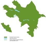
20 percent of Azerbaijan’s territory, including Upper (Nagorno)
Garabagh and seven adjacent districts, has been under Armenian
occupation since the two South Caucasus republics signed a
precarious cease-fire in 1994 following a lengthy war.
Here we are to serve you with news right now. It does not cost much, but worth your attention.
Choose to support open, independent, quality journalism and subscribe on a monthly basis.
By subscribing to our online newspaper, you can have full digital access to all news, analysis, and much more.
You can also follow AzerNEWS on Twitter @AzerNewsAz or Facebook @AzerNewsNewspaper
Thank you!